 The Lockyer-Valley, Queensland, was the site of February 11-1-2011's devastating floods, including the ferocious flash floods on Murphys Creek. It shapes the pathway of the waters heading down to Brisbane and overfilling the Wivenhoe Dam, which is poised above that city. These photos from Google-Earth showing the topography (the form of the land) give many clues to the severity of the flooding. This article also asks questions about the Wivenhoe Dam and Government responsibility for its overfilling. In the Murphy's Creek flash flood, it seems you had weeks of rain causing totally sodden land, which could absorb no more rain, so when there were 60 solid minutes of rain, the denuded floodplains must have been like a smooth bath-tub. If you look at the area, the Lockyer Valley is a patchwork of treeless crop-sown riverflats with very little absorptive capacity. All around the valley are hills, feeding the river system. You can see Forest Hill bang smack in a river junction on the right and Toowoomba far left. Running down by the center of the valley is a huge long tarmacked highway.

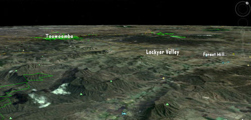
The Lockyer-Valley, Queensland, was the site of February 11-1-2011's devastating floods, including the ferocious flash floods on Murphy's Creek. It shapes the pathway of the waters heading down to Brisbane and overfilling the Wivenhoe Dam, which is poised above that city. These photos from Google-Earth showing the topography (the form of the land) give many clues to the severity of the flooding.
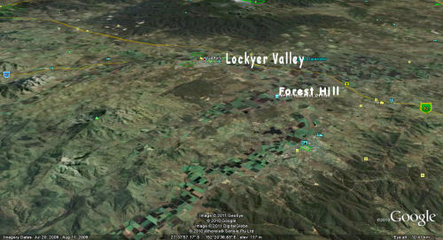
The principle landmarks indicated in the photos are the Lockyer Valley, with Forest Hill (from which most of the population was airlifted) on the right (East), and Toowoomba to the left (West).
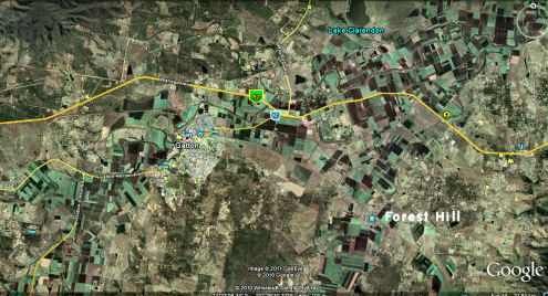
The photos show river-flats almost completely denuded of trees except for a thin fringe close to the permanent creek-beds. The trees that once covered the river-flats have been replaced by shallow monoculture crops, which look like greenish patchwork quilting fabric. Around the valley are hills, feeding the rivers. In the Murphy's Creek flash flood you had weeks of rain causing totally sodden land, which could absorb no more rain, so when there were 60 solid minutes of rain, the denuded floodplains must have been like a smooth bath-tub. You can see Forest Hill bang smack in a river junction on the right and Galton to the left of it and Toowoomba further left. Running down by the center of the valley is a huge long tarmacked highway.
Role of trees in reducing flooding

Although flash floods can happen in treed areas, trees and undergrowth create physical barriers to water and the trees themselves keep the water table down, acting like pumps, sucking the water down or transpiring it out their leaves back into the air. Trees can vary the amount of water they transpire enormously.
A tree is like a hydrological pump and a forest is like a huge hydrological factory.
Se also: Our Rain Garden on US web site www.teamleaf.org of Ladue Environmental Action Force.
Lack of trees reduced capacity of soil to deal with soaking
The lack of trees on these river flats meant that the soils had a lesser capacity to deal with water. As more and more rain fell and flowed down from the hills, the land ceased to retain it and it ran off like water on porcelain. The presence of trees would certainly have mitigated the severity of the flash flooding and the overall level of flooding.
Complex energy gradients attract life, including humans, but human activity simplifies them
It is normal for humans and other forms of life to be attracted to life where there is a confluence of energy gradients (places where thermodynamic forces concentrate, such as estuaries at the base of hills, where plants and animals thrive on mineral-rich soils and waters replenished from higher altitude sources. Powerful forces are involved, but kept in check by responsive natural systems. For instance, geological and biological structures cause rivers to slow down by forming obstructions. We simplify these natural features at our risk. We can minimise that risk by residing in modest numbers on high ground and minimising our impact on the biological and landscape systems.
Hurricane Katrina (New Orleans) an example of oversimplified landscape
Simplification of these systems makes through-put of energy faster and natural events more rapid and powerful. Another example of this was what happened in New Orleans because of the gradual straightening of the Mississipi River and the lowering of its banks by removal of oil and gas. Although levees were built, these were not complementary to the natural system and, when the government of New Orleans began to avoid topping up the levees, the city's vulnerability increased. Then a cyclone occurred and this famous modern city was almost completely destroyed.
How global competition removes safety margins from agricultural system
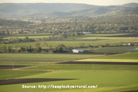
In rural areas that depend on agriculture, global competition drives farmers into desperately using every square inch of land for crops, simplifying biological systems of windy rivers and trees by substituting crops, bare earth and tarmac. They have to do this to pay interest on loans now necessary to purchase complex machinery to run their farms, and to pay for the cost of living which overpopulation had driven up by increasing the cost of land - at the base of all inflation. If farmers were allowed to produce modest amounts, they could ask for higher prices and have more control over their fates. If the general population retained some land to supplement their food production the impact on the land of farming would be spread out and less intense, so natural systems would be less affected. If our governments in Australia did not force up our populations we would be able to remain in stable communities without being forced to live on flood-plains, and our demand on the land would be less. We would be able to maximise the presence of trees and of biodiversity - of other living things which keep thermodynamic systems healthy and complex.
Brisbane's grossly engineered and simplified riverscape
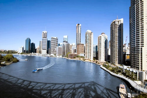
Our current land-use planning system - maximised for commercial profit rather than harmonious use - places us all in danger.
Brisbane is an example of a city which has housed its overpopulation on river-flats in a city where natural systems have been modified to an alarming degree. Whilst the engineering and construction feats along the river are impressive, and riding and walking along the concrete banks is convenient, it isn't sustainable or necessary. The river has been treated like a theme-park, but it is a living thing and a massive energy force, deserving of greater respect and less engineering.
A word about the Wivenhoe Dam Government responsibility
In the past few years Queensland, like much of Australia, has been in the grip of severe droughts. The Australian and Queensland governments encouraged high migration to Queensland despite the unreliability of water because they saw this as profitable to the property development industry with which they are entwined. It has been some time now since the drought broke in Queensland, yet water restrictions put in place during the drought have remained in force. This means that where Brisbane city dwellers could have taken long baths and showers and done heaps of washing, filled their swimming pools and watered their gardens liberally, they were discouraged from doing so. Meanwhile the Wivenhoe Dam filled up to 175 per cent (from memory thereabouts). The 100% refers to the water reservoir function of the dam and the 75 per cent refers to the flood prevention section.
The situation was becoming dangerously over-capacity, and so the government decided it needed to release large amounts of water into the river, despite the prospect of flooding, especially in the context of tidal inflow from the Bay. This has been done and the river is now flooding. People are asking why the Queensland State government failed at least to let people use the water before it got to such heights? That is only one of many questions being asked.
Responsibility for crazy Brisbane landscaping, land-use planning and building permit system
Brisbane mayor, Campbell Newman actually admitted on camera that he had realised that the Wyvenhoe Dam would not prevent another flood event like the 1974 one. He admitted this, yet he has presided over the creation of underground road-tunnel systems and the packing in of more and more dwellings in Brisbane, along the river and on low ground.
Another big question is a two-part one: Firstly, why did the government allow homes to be built on the river flats below the level of the 1974 high-mark or the higher one of the 19th century floods? The second part of that question is, can members of the government who had authority in this matter be held criminally responsible for the consequences?

 The Lockyer-Valley, Queensland, was the site of February 11-1-2011's devastating floods, including the ferocious flash floods on Murphys Creek. It shapes the pathway of the waters heading down to Brisbane and overfilling the Wivenhoe Dam, which is poised above that city. These photos from Google-Earth showing the topography (the form of the land) give many clues to the severity of the flooding. This article also asks questions about the Wivenhoe Dam and Government responsibility for its overfilling. In the Murphy's Creek flash flood, it seems you had weeks of rain causing totally sodden land, which could absorb no more rain, so when there were 60 solid minutes of rain, the denuded floodplains must have been like a smooth bath-tub. If you look at the area, the Lockyer Valley is a patchwork of treeless crop-sown riverflats with very little absorptive capacity. All around the valley are hills, feeding the river system. You can see Forest Hill bang smack in a river junction on the right and Toowoomba far left. Running down by the center of the valley is a huge long tarmacked highway.


Recent comments