AWPC writes that only two of its questions were answered satisfactorily. It asks Melbourne Water what happens to the wildlife after the clearing? “The AWPC, wildlife rescuers and shelters regularly experience the fallout of such projects. Consultants and wildlife handlers are contracted at a premium price, only to hand over displaced, orphaned and injured wildlife to either vets or local wildlife shelters who are then expected to deal with these sentinel beings at their own cost. Quite frankly this is unacceptable and needs to stop, which is why the AWPC ask you the following questions once again.” Inside, full correspondence to date.
Craig Thomson
President, Australian Wildlife Protection Council
502 Waterfall Gully Road, Rosebud 3939
[email protected]
0474 651 292
Mark Lawrence
Melbourne Water Project Manager
990 La Trobe Street Docklands VIC 3008
PO Box 4342 Melbourne VIC 3001
[email protected]
Dear Mr. Lawrence,
Re: your response to my email sent 23/1/2018 about the ‘Lee St Retarding Basin Upgrades’
Overall, it was a very disappointing response, especially as most of your answers are already available on your community information sheet. Only two questions were answered satisfactorily; were you confirmed that you have forwarded my query about the sale of Melbourne Water land to the relevant department and the dates of the pre-fauna survey. We have spent a great deal of time putting these questions to you because of the lack of information provided by Melbourne Water to concerned members of the community.
Is Melbourne Water concerned about genuine community consultation and being transparent to the community to whom they provide an essential service? The Australian Wildlife Protection Council (AWPC) will be putting in a Freedom of Information request for the documents you have not supplied, including the ecological/fauna reports, however we will also complain to the concerned ministers, local councilors and community members about Melbourne Water’s lack of openness and communication. We believe you are scaring the community to justify these works whilst refusing to be transparent about the true risks. This is highlighted in your reply, by the following text, coupled with the fact that you are asking us to then submit an FOI for proof of this.
“Failure of the embankment would have a significant impact on a number of properties in the area.”
As you have identified, we are particularly concerned about the impacts on wildlife with the removal of vegetation; of the fifteen questions we sent to you eight are about wildlife. We ask Melbourne Water what happens to the wildlife after the clearing? The AWPC, wildlife rescuers and shelters regularly experience the fallout of these projects. Consultants and wildlife handlers are contracted at a premium price, only to hand over displaced, orphaned and injured wildlife to either vets or local wildlife shelters who are then expected to deal with these sentinel beings at their own cost. Quite frankly this is unacceptable and needs to stop, which is why the AWPC ask you the following questions once again:
1. Which wildlife rescue groups, wildlife shelters and vets have been contacted to look after or treat any injured wildlife?
2. Do local wildlife shelters have the capacity to look after injured wildlife during this busy time of the year?
3. What arrangements have been made to financially compensate these groups?
4. What measures have been taken to install nest boxes or other artificial habitat for displaced wildlife? (Please note that installation of nest boxes needs to be carefully planned in advance so as to enable wildlife to be bonded to new nests before re-release).
5. Do the contracted ‘wildlife handlers’ have appropriate wildlife handling experience as well as knowledge of the legislation about the re-location of wildlife.
6. Do the ‘wildlife handlers’ possess the appropriate permits to have protected wildlife relocated within a safe distance from their habitat loss or will animals be euthanased?
If Melbourne Water maintain, “Protection of wildlife is of great importance to Melbourne Water and we have committed to implement the handler’s recommendations” does Melbourne Water also commit to answering our questions for the ongoing protection of wildlife who will be effected by this project?
We can only assume, from your response, that the only community engagement so far planned by Melbourne Water, is to provide wood from the felled trees to various groups to make furniture. Yet, the community groups who will be most effected like environmental groups, wildlife rescuers, wildlife carers and shelters have not been included in this process what so at all!
To indicate that you are only going to plant 30 canopy trees within Frankston, in a place yet to be identified, does not seem to be fair compensation for the loss to the local environment. How did Melbourne Water come to this conclusion? Are these trees to be planted by community volunteers or are there to be separate plantings by contractors? The AWPC has identified a number of suitable sites close by, owned by Melbourne Water for these plantings.
We look forward to your reply and answers to our questions and we at the AWPC are happy to consult with Melbourne Water and/or your ecologist consultants to work on a better plan, communication and management for the future of this project.
Yours sincerely,
Craig Thomson
President, Australian Wildlife Protection Council
LETTER TO PRESIDENT CRAIG THOMSON FROM MARK LAWRENCED, MELBOURNE WATER PROJECT MANAGER
Mr Craig Thomson
President
Australian Wildlife Protection Council Inc.
[email protected]
Dear Mr Thomson
Thank you for your email enquiry regarding safety upgrade works at the Lee Street Retarding
Basin in Frankston.
We understand that you are concerned with the planned tree removal at the site and the
impact this may have on wildlife and their habitat.
Under Melbourne Water’s Statement of Obligations (2015) issued by the Minister for Water, we
are required to assess all existing retarding basins against the Australian National Committee
of Large Dams (ANCOLD) Guidelines. An assessment of the Lee Street Retarding Basin against
these guidelines identified that the site does not comply and safety upgrade works are required
to continue to reduce flood risk for the local community.
To ensure Lee Street Retarding Basin continues to operate safely and comply with the ANCOLD
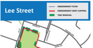
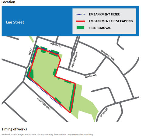
guidelines, trees and vegetation on the length of the embankment will need to be removed as
part of the works. We have worked hard to ensure that we only remove trees that will affect
the integrity of the retarding basin and have committed to planting trees at other locations in
the Frankston City Council area.
The ANCOLD guidelines are publically available and a copy can be purchased online from
ANCOLD at their website: www.ancold.org.au The guidelines do not specifically mention trees
on retarding basin embankments. They provide guidance on how to assess risk on dams and
dam-like structures.
In the past, it was common practice to have trees on retarding basin embankments. However,
as international understanding of dam engineering has improved it has become evident that
trees significantly weaken embankments and increase the risk of failure in a high rainfall
event. Failure of the embankment would have a significant impact on a number of properties in
the area.
In 2015, Melbourne Water received independent specialist advice that trees on retarding basin
embankments increase the chance that the embankment may fail in the event of a large rain
event. The chance is increased due to:
“internal erosion and displacement of soil – tree roots create erosion pathways
through the embankment which are worsened when the tree dies and its
decaying roots leave voids through the embankment;
“trees uprooting and taking part of the embankment with them; and
“water speeding up around tree trunks and causing faster erosion.
As part of the works, the embankment must also be hardened to operate safely and this can’t
be done without the trees being removed.
We understand the importance of trees to the local community and have committed to
mitigating the impact of removing the embankment trees by:
“planting 30 canopy trees elsewhere in the Frankston City Council area;
“using the cut-down logs to provide a woodland habitat for wildlife at Lee Street
Retarding Basin; and
“recycling the cut down logs to make furniture that will be donated to Frankston
City Council.
A reinstatement plan has been developed in adherence to Frankston City Council’s Local Law
22 permit requirements and we will implement it in the coming months. In addition to the
reinstatement plan, wood from the trees at the site will be utilised by a local community group
and the community will also have an opportunity to participate in a planting day in Frankston
in coming months.
As part of the planning for the project, Melbourne Water engaged specialists to complete a
flora and fauna assessment and arborist assessment as part of Council’s requirements under
Local Law 22.
In your email you asked us to provide you with the arborist report and water depth and flood
modelling records. We ask you to request these under the Freedom of Information Act 1982
(Vic) to make an FOI request, please visit our website and use the online FOI application:
www.melbournewater.com.au Our FOI Officer, Michael Keough, is available to assist with your
application if required. Michael can be contacted on 9679 6821 or at
[email protected]
In addition to the flora and fauna assessment we have engaged a wildlife handler who will
manage and implement the wildlife management practices prior to and during the tree removal
activity. Protection of wildlife is of great importance to Melbourne Water and we have
committed to implement the handler’s recommendations including:
“undertaking a pre-construction visual inspection and assessment at Lee Street retarding
basin. This was completed on 29 January 2018 and found no EPBC Act-listed threatened
ecological communities or FFG Act-listed threatened flora communities present within the
Lee St study site.
“marking trees that have possible habitat to ensure that they are removed appropriately.
“confirming the species as listed in the flora and fauna assessment
“remaining onsite during the tree removal works to check and safely move fauna prior to
tree removal.
The wildlife handler we have engaged is a qualified ecologist and zoologist with 25 years’
experience.
The EPA guidelines referred to are in relation to hours of work. Work for this project will be
carried out in line with EPA guidelines between 7am and 6pm Monday to Friday and 7am and
1pm on Saturdays.
Your email included concern at the sale of Melbourne Water land in the Frankston area and the
potential loss of biodiversity. We have passed this on to our Property Team who will respond to
you direct.
Once again, thank you for your email.
Yours sincerely,
Mark Lawrence
Melbourne Water Project Manager
ORIGINAL LETTER FROM CRAIG THOMSON TO MELBOURNE WATER ABOUT REMOVING TREES FROM LEE ST RETARDANT BASIN
Letter from Craig Thomson, President AWPC
Dated 23 January 2017.
Subject: Lee st Retarding Basin Frankston
Addressed to: [email protected] (Biodiversity Officer at Frankston Council), [email protected] (Minister for Police and Water) [email protected] (email address for Melbourne Water retardant basin upgrades).
The Australian Wildlife Protection Council understands and recognise the needs to protect our communities from potential danger. We are also aware that the removal of vegetation has an impact on wildlife species. In fact it is a guarantee that wildlife will be killed during works that clear vegetation. As such we expect that every possible measure is undertaken to see if in fact clearing is necessary and if so that appropriate actions are taken and that local wildlife shelters are not left too pick up the pieces of poor planning.
We have received concern from the local community members that the threat of flooding to the local community at the Lee St retarding basin has not deemed a risk in the past and believe the proposed clearance of vegetation is excessive and will have significant impact on fauna as well as other issues, particularly of erosion and dust as well. So the Australian Wildlife Protection Council would greatly appreciate if you could answer the following questions;
-What pre-fauna surveys have been carried out and when?
-What species have been identified on site?
-What are the actions have been put into place for fauna pre, during and post construction activities for fauna?
-Which wildlife rescue groups, wildlife shelters and vets have been contacted to look after or treat any injured wildlife?
-What arrangements have been made to financially compensate these groups?
-Do local wildlife shelters have the capacity to look after injured wildlife, as they could be attending to heat stress events or bushfire effected wildlife?
-What measures have been taken to install nest boxes or other artificial habitat for displaced wildlife?
-Do they have appropriate wildlife handling permits as well as permits to have protected wildlife euthanised if injured or unable to relocate wildlife in a safe distance from their habitat loss?
-What community groups have they contacted to work with as stated in their community information sheet? [Ref: ] “We understand the importance of trees to the local community and are committed to working closely with council, residents and community groups to develop an appropriate plan for reinstatement of trees else where in the area” in the information document provided for this project https://www.melbournewater.com.au/files/2018-01/Communitybulletin-LeeStreet.pdf
-Where are other trees being planted, what species are to be planted and how many?
-Are offsets being provided?
-Is there an arborist report of the trees health?
-Can records of water depth be provided for the Lee St retarding basin to show threat of flooding to neighbouring properties over the years of its existence?
-Can modelling or records be provided of local flooding for once in a 40+ year storm event?
-What are the EPA regulations you are keeping to with to for this project?
-Can you provide a copy of the ANCOLD guidelines?
The Australian Wildlife Protection Council also has the understanding that you are in the process of selling off land on McClelland Dve to Ambulance Victoria for an ambulance station and another permit application has been made by Log Cabin Caravan Park. In fact we believe that all land owned by Melbourne Water from Skye Rd to Frankston/Cranbourne Rd is being considered surplus land by Melbourne Water. So it appears there are several sites across the Frankston city council municipality owned by Melbourne Water that poses a potential loss of biodiversity.
So the final question we have to you is what is Melbourne Water’s commitment to biodiversity in Frankston?
 The memorial service honoring Frankston environmentalist Olwen Margaret Bawden has been put back until next week on Saturday 22 March, and the venue has changed to The Frankston Arts Centre, Cube 37, between 2pm and 3pm. But on Saturday 15 March 2025, The family Autumn Picnic will proceed from 12.00 to 2 pm at Seaford Senior Citizens' Hall, Broughton Avenue, Seaford.
 Paul Edbrook, State Labor MP for Frankston, has repeatedly failed to respond usefully to complaints from constituents regarding the forced accommodation of a Metropolitan Activity Centre under the increasingly authoritarian regime of Premier Jacinta Allan's Victorian Government. Inside this article, we have published two complaint letters, along with the negligent and empty responses from Mr. Edbrook or his staff, despite the great importance of the matter.
 6.30pm Feb 6, 2025, at Seaford Community Centre: Talbot Hall or (depending on the weather) in the shade on the lawn between the Hall and the Creek. Public meeting to discuss the future of Kananook Creek Corridor planning. Please join us in attending to show your support for the Kananook Creek Association (KCA). FCC has dissolved the Kananook Creek Governance Group without consultation.
 The Frankston Beach Association has expressed deep disappointment in Frankston City Council’s decision to discontinue the Kananook Creek Governance Group, saying that this decision, made by the new Council on Monday, 2 December 2024, reflects a concerning lack of transparency and consultation.
  Jenny Warfe delivered this submission and spoke to it verbally at Planning Panels Victoria, Frankston hearing on C160fran Ammendment. The Amendment would mandate population growth-engineering and a mega city in Frankston, at the head of the Mornington Peninsula, on Port Phillip Bay. Port Phillip Conservation Council (PPCC) Inc.
 Currently Planning Panels Victoria is sitting in Frankston and hearing multiple objections to the State Government plans to force Frankston to absorb a continuously increasing number of new people, in order to provide profits to the Property Development and Finance oligarchy that has basically taken over much of government policy and planning in Victoria. We begin by publishing the summary of Sheila Newman's verbal submission to the Planning Panel given 4 July 2024, with her


 Frankston's 170th Anniversary was on the 29th of May.[1] Frankston's first official land sales were on 29 May 1854, illustrated below with a map showing the lots. The plan for the new village of Frankston was drawn by James Philp from the Office of
 Stop the Great Wall of Frankston and others call for people to come and join us at 11 am this Saturday on Kananook Boulevard at the Rear of Harbour site (next to rear of McDonalds).
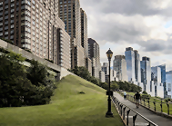 Frankston Beach Association: "The fight to save our coastal amenity from high rise buildings along Kananook Creek is not yet over despite the Minister overturning the decision to impose 3 storey mandatory height limits along the precinct.
 There is exciting news from Frankston. On Wednesday Victorian Planning Minister Sonya Kilkenny announced an Interim Design and Development Overlay which included mandatory height limits of 3 storeys on the section of land between Kananook Creek Boulevard and Nepean Highway.
 Rally to “Stop the Great Wall of Frankston,” Saturday 13th May at 10.30 AM, Corner Wells St. and Kananook Creek Frankston. Planning Applications are at Frankston City Council for 14, 15 and 16 storey apartment blocks of up to 60 metres height on the beachside of Nepean Hwy, and only 200 metres from Frankston’s scenic beach. The towers would overshadow Kananook Creek, the beach, nearby homes, exacerbate wind tunnel effects and change the face of Frankston forever.
  The following message about shocking proposals for a wall of multistorey appartments on the fragile banks of Frankston's much-loved Kananook Creek, was sent on 12 January 2023 to members and friends of The Port Phillip Conservation Council.
 Victoria Police has decided to withdraw speeding infringements issued between 15 April 2022 and 16 June 2022 for driving at speeds of up to 60km/h, at the intersection of Nepean Highway and Davey Street, Frankston. Speeding infringements issued for exceeding the 60 km/h may still be enforced.





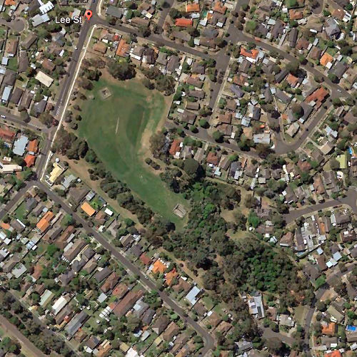
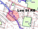 Alan Hood is a Flood Researcher. Melbourne Water owns this Retarding Basin and their maintenance contractor, John Holland - KBR Joint Venture intend removing trees and various works in "late January" - any day now. This could be an attempt to cater for increased suburban stormwater runoff without increasing the capacity of the chain of retarding basins. Although prepared for dams which would normally be at least 10 to 15 m high, ANCOLD guidelines can also be used to assist with decisions on smaller dams, particularly where such dams create potential loss of life or significant damage. The attached Planning map shows Special Building Overlays (SBO) for Frankston; the identify areas likely to be flooded. If the Lee St Retarding Basin batters are at least 10 to 15 metres high, there might be some justification for removing the trees, but see more inside this article. [Introduction written by candobetter.net editor.]
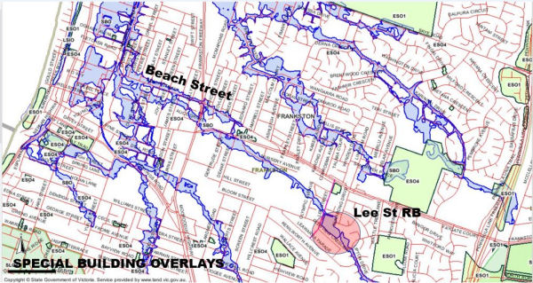 The Australian National Committee on Large Dams says: “ANCOLD guidelines are applicable for water or tailings dams with potential to cause loss of life or significant environmental or physical damage through operation or failure.
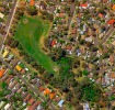 Melbourne Water is about to de-tree Frankston koala corridor by removing mature trees from banks of a huge park with a water retarding basin in it at Lee Street Frankston 3199. They are claiming that the trees are 'destabilising' the banks. But of course the trees are holding the banks together and keeping the water-table down. Who is accountable for these kinds of decisions that are based on what sound like lies that make no sense? Frankston Council is apparently going along with this. It seems totally insane and anti-life and nature. Inside is a video alerting us to the details.

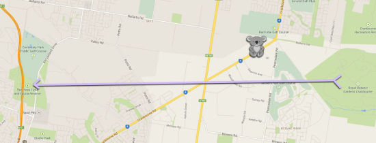
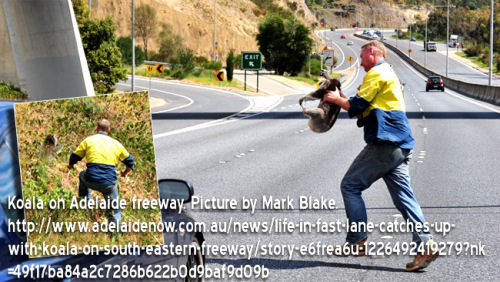
 Today at the Australian Wildlife Protection Council AGM I interviewed Craig Thomson, Animalia wildlife carer, about the events that may have led to Sean the Koala travelling down a busy highway in Langwarrin. Turns out he was probably following a traditional migratory route of male koalas in search of romance, which takes them from islands of habitat like the Cranbourne Botanical Gardens, down four-lane highways towards The Pines Flora and Fauna Reserve in Frankston, or further south, across the massive Peninsula Link tollway that cuts the Peninsula in half. Why are koalas being forced onto highways? It is another terrible cost of the unwanted human population expansion that is being forced on Victorians by the State Government, in its bid to grow Melbourne faster and faster. Animalia has $10,000 outstanding power bills; you can help by donating to WESTPAC BANK BSB 033138 Account 434072
 Melbourne’s outer suburbs have accommodated almost half of Victoria’s undemocratically imposed population growth during the past five years, yet they have been allocated only seven percent of the Napthine Government’s 2014/15 budget for key infrastructure.
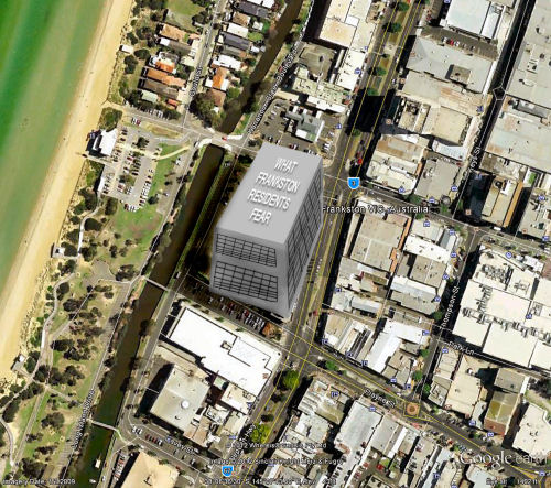
 Monday 10 December Frankston Council will approve the design of the South East Water (SEW) high rise Office Block. The building is 8 -9 story high (potentially 10 in the future) and extends for an entire city block from Playne Street to Wells Street. Public space is being rapidly chewed up in Frankston. It lost its Central Park in the Town Centre to Gandel over ten years ago. It looks like losing the long planned Kananook Creek Boulevard (connecting the town centre to the waterfront) to a South East Water office tower and a new aquatic centre is swallowing up existing parklands. Another crucial issue is due process and secret deals.
 Freeway proponents' argument for clearing push prior to provision of net gain offsets:

Recent comments